|
The Big Idea: Geographic factors promote or impede the movement of people, products and ideas.
|
Learning Targets:
|
Notes - The Middle East and Arabian Peninsula
Use the Prezi presentation to fill in the notes sheet about key vocabulary and the Arabian Peninsula. If the Prezi is not visible below then click the link to get on it! Remember, use the arrow key to go through the Prezi in order!
Map Activity - The Arabian Peninsula & Surrounding Areas (also known as the Middle East)
DIRECTIONS - Complete the each Map in the packet using the directions below. There are 3 total Maps and each has labeling instructions.
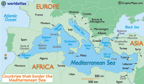
Map # 1 - The Mediterranean Region
|
STEP 1 - Label the following bodies of water:
1. Mediterranean Sea 2. Black Sea 3. Bosporus Strait 4. Atlantic Ocean -Color them BLUE STEP 2 - Label the following cities: 1. Rome 2. Constantinople -use a black dot to show where they are |
STEP 3 - Label the following continents:
1. Europe 2. Africa 3. Asia STEP 4 - Compass 1. Draw a Compass to show direction. |
Map # 2 - The Arabian Peninsula and Surrounding Regions (Middle East)
|
Step 1 – Label the following areas.
1. Arabian Peninsula. 2. Africa (you should know this. If not, ask a friend) 3. Europe (you should know this. If not, ask a friend) 4. Asia (you should know this. If not, ask a friend) Step 2 – Label the following bodies of water. 1. Mediterranean Sea 2. Black Sea 3. Red Sea 4. Indian Ocean 5. Persian Gulf 6. Bosphorus Strait 7. Nile River -Color them BLUE Step 3 – Label the following cities. 1. Istanbul (was Constantinople) 2. Baghdad 3. Medina 4. Mecca -Use a black dot to show where they are. STEP 4 - Compass 1. Draw a compass to show direction. STEP 5 - Trading on the Peninsula... 1. View the map that outlines the trade Routes used on the Arabian Peninsula and draw them on your map (Button below). 2. View the Presentation about what goods were traded on these routes and list at least 3 goods and where they came from on your map.
|


| ||
Map # 3 - Eastern Hemisphere

STEP 1 - Label the following bodies of water
1. Atlantic Ocean
2. Indian Ocean
3. Pacific Ocean
4. Mediterranean Sea (you can abbreviate)
- Color in BLUE
STEP 2 - Label the following continents
1. Europe
2. Africa
3. Asia
4. Australia
STEP 3 - Outline
1. Outline the Arabian Peninsula and Surrounding Regions in RED - you can choose to either include Egypt or not. It is up to you.
STEP 4 - Compass
1. Draw a Compass to show direction.
|
The red marker on the map below shows where we live!
|
Check on the Google Map below to see the modern day political borders of the countries in the Middle east region.
|